Isaias expected to strengthen into major hurricane near Bayou La Batre
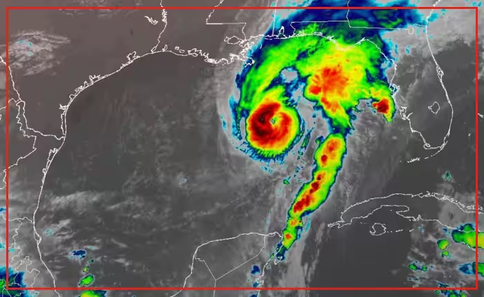
Isaias was forecast to strengthen into a Category 3 system near Bayou La Batre on Friday. Forecasters warned residents along the shoreline to prepare for dangerous winds and life-threatening storm surges. Landfall was projected for late Friday near the Alabama-Florida state line.
The system carried sustained winds of 110 mph (177 kph) early Friday. Those winds placed the storm just below major hurricane status, according to the National Hurricane Center.
Landfall was expected between Mobile Bay in Alabama and Choctawhatchee Bay in the Florida Panhandle. Forecasters stated the storm would weaken quickly over land.
“Preparations should be rushed to completion as the weather will go downhill quickly today. While the storm is not expected to make landfall at peak intensity, it is likely that Isaias will still be a significant hurricane when it reaches the coast.”
The system was centered 200 miles (322 kilometers) south-southeast of the mouth of the Mississippi River. It tracked north at 15 mph (24 kph), the center said.
A hurricane warning spanned Ocean Springs, Mississippi, to the western Florida Panhandle. Tropical storm warnings covered areas from southeastern Louisiana to the Aucilla River on the Big Bend in Florida.
Coastal water levels could rise 5 to 7 feet (1.5 to 2 meters) above ground, forecasters said. The storm also threatens flash flooding and tornadoes.
Alabama Gov. Kay Ivey ordered non-residents to evacuate Gulf Shores, Orange Beach and Dauphin Island on Thursday. Social media videos showed stalled highway traffic leaving Gulf Shores. Water access was closed there under double-red warning flags.
Dozens of counties entered states of emergency across Alabama and Florida. Florida Gov. Ron DeSantis said approximately 5,000 National Guard troops were expected to mobilize by Friday.
Officials on Dauphin Island encouraged voluntary evacuations on the western end. Dauphin Island Mayor Jeff Collier described the storm threats with caution.
“We just have to be prepared for the worst.”
In the Pacific Ocean, Hurricane Simon formed off Mexico on Wednesday and became a hurricane Thursday. Forecasters expected Simon to intensify into a Category 4 system.
The National Hurricane Center tracks tropical systems across the Atlantic and eastern Pacific basins. Category 3 and higher storms are classified as major hurricanes capable of devastating wind damage.
The storm will weaken to a tropical storm along the Alabama-Mississippi border near Bayou La Batre by Saturday afternoon, forecasters said.