Isaias weakens after Destin landfall but leaves widespread power outages
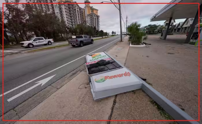
Isaias struck near Destin, Florida, as a Category 2 hurricane Friday evening before rapidly losing wind strength. The storm knocked out electricity to hundreds of thousands of homes and businesses across the region. The system was the first hurricane of the Atlantic season.
Isaias quickly downgraded to a post-tropical cyclone overnight. Its sustained wind speeds dropped to 35 mph as it pushed into Alabama. Threats of flash flooding and possible tornadoes continued across the area Saturday. Life-threatening storm surges remained a risk along the coast.
More than 911,000 utility customers in Florida, Alabama and Georgia lost power early Saturday, according to poweroutage.com. Officials in Mobile reported downed trees and fallen utility wires. Flooding and storm debris closed roads in Houston County in southeastern Alabama.
In Pensacola, Florida resident Tim Mowry rode out the tempest at home. He noted the wind sounded like a train whistle through his patio door. Parts of his fence fell, and his yard flooded.
“As far as Pensacola-wise we really got fortunate,” Mowry said.
Mowry used a generator for power. His son could not drive to his house because fallen trees blocked streets. High winds ripped the roof off a hotel elsewhere in the city.
Pensacola Mayor D.C. Reeves said on Facebook that the airport sustained some damage. Reeves reported power failures downtown along with downed trees across town.
Florida Gov. Ron DeSantis reported no confirmed fatalities from the storm. DeSantis confirmed that all state-owned bridges and major thoroughfares are open. Heavy rain continues to threaten communities east of the system.
“The risk of flooding is still high,” DeSantis said. “Sometimes these things happen a day or two days after the storm goes through. So the flooding story is not over.”
Farther south, Simon became a Category 4 hurricane off the coast of Mexico. The National Hurricane Center in Miami said Simon reached sustained winds of 150 mph. The center said the major hurricane could produce 10 to 20 inches of rain in southwestern Mexico, with local totals reaching 30 inches.
A National Hurricane Center bulletin urged Mexican residents to prepare immediately before a projected Sunday landfall. Dangerous tropical storm winds could arrive well ahead of the center of Simon. Forecasters expect the heaviest rainfall in Jalisco, Michoacan, Colima and Nayarit.
Post-tropical cyclones often lose their warm core structures while maintaining strong surface winds. Emergency teams check bridges and utility corridors immediately following major weather events. Road crews work to clear fallen debris from evacuation routes.
Utility workers continue repairing distribution networks in Destin and surrounding counties to restore electrical service. Emergency managers urge drivers to avoid flooded roads.